


Bermuda
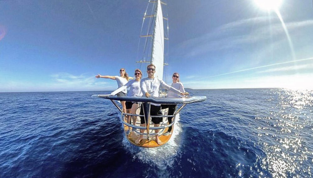
/Rosehearty versus Team GB and Sir Ben and Team Australia and Tom Slingsby. Note they both had to duck us as we were on Starboard

Sail GP
/A lot of water under the keel since the last Post. Many disruptions to our world in these virus infected times.
We did manage 16 day charter in the Grenadines but we sat extensively in lockdown in Antigua with nowhere we were able to go. So we finally felt relief as we sailed up to Bermuda, things had been good there since the beginning of the year. However sadly the day after we arrived the country went in to full lock down..
We did however get to go out on Rosehearty and Watch the SailGP races, albeit without the guests we were supposed to have onboard. so here a few photos of what was an incredible sailing event. Even if there was only us there and no social activities. If you ever get a chance to see these machines you really should go.

Sun Sights
/So Atlantic crossings are easier these days as you just follow the dotted line over the ocean, right? Well it is good to see that the younger generation wants to learn the old skills of Celestial Navigation. Here Jayde reduces a sun sight. In the old days a morning sight crossed with the noon sight would give you a fair position, add in an afternoon line of position and perhaps the pole star or the early morning basket of stars and you would be pretty confident on your position. The more you do them the more accurate they become like any skill.

24 hours on the Bow!
/The first 24 hours of any ocean delivery are crucial and tend to set the tone for the trip ahead.. it’s ‘so far, so good’ for us Rosehearties out here in the big blue on day 2, with 11 happy crew members settling into the routine of a couple of weeks ahead at sea.
Our last glimpse of land was in the early evening last night as the coast of Morocco faded into the clouds behind us, nothing but 360 degrees of horizon from here until we reach our destination which is 3000 nautical miles away.
The weather ahead is looking good so far and morale is high. A perfect opportunity to snap some photos from the bow of the sails, a glistening ocean and our interior team stay tuned for updates from our passage across the Atlantic. Safe sailing and happy Weekend
Gibraltar
/A beautiful sunrise over the Rock of Gibraltar, our final beacon departing Europe The rock is famous for many reasons but it is most recognized as a heavily fortified British air and naval base that guards the Strait of Gibraltar, which is the only entrance to the Mediterranean Sea from the Atlantic Ocean. The rock is also home to a protected reserve of Barbary Apes (the only wild monkeys in Europe) who have earned themselves the traditional belief from centuries of sieges that “so long as the monkeys live on the Rock, so too will the British have control”...
In front of us is over 3200 nautical miles of open ocean to our Caribbean destination, and Rosehearty is ready to cruise the Atlantic to warmer waters see you on the other side
We need to cross slowly as even being tested, negatively on departure we need to take 14 days to cross. We usually cross in about 11days. Maybe slow enough to fish!

Written by Jayde Couyzn
Panthera
/Hanging with the new friend


Man of Steel, ohh and a nice Paint Job.
/Just after crossing the Bar. We had waited 2 days to get over said Sand bar at the entrance. There was more swell than we thought and it was a bit sketchy at one point but We got over and headed South to Elba

Escape from the Shipyard
/We finally departed Viareggio on Wednesday the 4th of August. it was an 11 month stop. It was also a full refit, of everything including paint. We all bonded together during to lockdown, and when the work restarted we found that Perini were insolvent. so the crew rolled up there sleeves and finished the job. What a team!

Photo by Richard Smith
Reflections
/It has been the most amazing year for Rosehearty. Sometimes it takes a while for everything to sink in. We are in the yard in Viareggio giving Rosehearty some love and attention. Meanwhile we remember some of the wonderful experiences that we have had on board. This is NYC . The Iconic Statue of Liberty and Rosehearty.
What a great week we had there in June, watching the F50’s race on the Hudson..and then a lovely mini cruise with family and friends in New England.


To Viareggio
/Every ocean voyage has its challenges and for each one there are usually one or two moments that stand out. On board Rosehearty, on her passage from Nuuk, Greenland to Viareggio, Italy, we seemed to have an abundance of these moments. At the time, as we persevered along our route, the challenges felt onerous. There were no freebies on the trip; every mile had to be earned. But in the end, both boat and crew succeeded, not without a few nicks and dings, but with an abundance of pride for having been handed a tough stack of cards and doing with them what needed to be done.
The following poem is dedicated to the Mighty Rosehearty, her passionate Owner Joey, Her stalwart crew and to Captain Markus, who when leaving Nuuk, drew coins from his pocket and offered them to Neptune
RoseMightyHearty
He paid his dues to Neptune,
Just as we left the dock.
The coins flew high in icy air,
And sank as quick as rocks.
“That's it,” we thought, “our tolls all done.”
We headed out to sea,
We didn't hear that tiny hiss:
"I have more plans for thee."
Perhaps it was the currency
Or other unknown slight,
But Nuuk to Europe will go down
As Neptune's trip of spite.
Each gate we passed, we paid our fee,
And hoped we would be done.
But Neptune rubbed his hands and said,
"I'm having too much fun."
In waves and wind we travelled south
Escaping hurricanes;
And then were handed fog and ice,
To ratchet up our pain.
We forked our payments over,
No sleep and pounds of stress;
The fines were taken willingly;
Neptune un-impressed.
Next came the big sou'wester
The bottom of a deepening low;
We slunghsot out into the high,
And my did that ridge blow.
Near Spain we got our fifty knots;
The sea grew large and wild.
The big one came just after dawn
And laid us on our side.
The rail went under water
As did the aft deck too;
But back she came to fight again
Rosemightyhearty true.
The Straits of Gib collected,
With 40 knots and traffic;
“We must be finished paying!”
But Neptune would not have it.
He'd other trials in store for us,
A little further on:
Square seas and lots more headwinds
Cabo de Gata -- for an eon.
The last wave was the biggest.
We dropped from a velvet sky;
Cement trough there to greet us,
Green water rushing by.
It buried all the foredeck,
The mast and hatch for crew
It smashed into the wheelhouse,
And flybridge windscreens too.
The tolls were getting pricey,
The crew was out of cash;
Would Lyon make us take a loan
And really kick our ass?
At first we did not think so,
The day dawned clear and bright
But soon enough the swells rose up
And rolled us through the night.
"Surely, sir, you must be done,
And happy with your purse."
The wind went aft, we breathed our gas,
It couldn't get much worse!
We all felt green and nauseous,
We gasped and spat and swooned.
Neptune curled with laughter,
And cackled like a loon.
“That must be it, no more pray tell,
Our credit's all used up.”
"Find a way, you have to pay
I'm holding out my cup."
Sand bar in Viareggio,
Would be our final gate
The swells they broke across it
And made us sit and wait
But patience is a crucial skill,
True sailors understand;
Use what nature gives you,
And then she'll lend a hand.
So pay we did along our route
With dollars, yen and kroner
The more we gave, the more he took:
How did we earn this honor?
The sea's a jealous mistress;
She seeks your whole devotion,
And often will remind you
With indifference or commotion.
We passed our test;
We paid in full --
No wining or complaining.
Neptune grinned a cheeky smile:
"I'm happy with your training"
And so to you, my fellow crew
On board Rosemightyhearty:
Let's toast the boat that kept afloat
And get on with our PARTY.
--Jonathan
10 Sept 2019


The Best Laid Plans
/
About the same time Rosehearty was arriving in Nuuk, Greenland, Tropical Depression #6, 200 miles southeast of Cape Hatteras became Tropical Storm Erin. We had just finished a 21-day, 1300 mile Arctic expedition. After weeks of extraordinary yet challenging cruising, the whole crew was looking forward to a few days dockside, a couple of days off and at least one night of 8 hours continuous sleep. For the work days, the crew would tackle routine provisioning, fueling, and pre-sea checks. Days off would feature sleep, hikes, and dinners out. As we threw the heaving lines to the waiting line handlers, we could taste that first glass of wine in three weeks, smell the roasted musk ox and reindeer we wanted to try, and feel the soft embrace of our duvets and pillows on those mornings we would be allowed to sleep in. This would be our last port of call before setting off for Viareggio, Italy, 3,500 miles away.
But as is often the case in large yacht programs, what you think is going to happen, changes, usually due to weather, schedule, boat or a combination of all three. Within 15 minutes of docking, it became clear that our dreams of uninterrupted sleep were shattered. The 15-foot tides and rough commercial dock would mean hourly monitoring of lines and fenders. Within an hour of docking, we realized that the relatively short work list we had intended to burn through on arrival so we could have the rest of the day off would not even be touched because we would spend the next 7 hours shifting the boat forward and aft in order to give room to the commercial trawlers and ferries arriving in Nuuk to discharge their catch or their passengers. And within 8 hours of docking, when we finally rested in our final position and could take a moment to review our preferred schedule over the next 5 days, we realized that the departure window as currently set – based on days off, crew arrivals and departures, and provisioning -- would not be feasible. If we waited the 5 days to enjoy an orderly, restful turnaround, we would be departing into storm headwinds. TD6, now Tropical Strom Erin, was strengthening and accelerating and headed towards Greenland.
And so the crew smashed out 4 days work in 2, woke up every hour to adjust lines and fenders, took half a day off, and had Rosehearty ready for the 3500 mile sail to Italy by late afternoon, just 72 hours after our arrival. We did get to try grilled reindeer and enjoy a glass of red wine. A strong northerly surge was forecast for the first 24 hours, and though we would have preferred to wait for milder conditions to dock out, the 36 and 48 hr forecasts predicted a fast change to strong headwinds along our track and so we opted for an evening departure in to near gale conditions from behind, rather than waiting and risk running into gale winds from ahead.
The northerly winds were strong and cold as we made our way from the protected waters of Nuuk towards the open ocean. Shrieking gusts funneled through the island passages. Large ice bergs lay grounded in the shallows. Having moved south from the arctic circle, our 22 hours of daylight were gone. The sun would set at 930pm and we would have darkness until about 5am. On the one hand, we welcomed the change, the chance to re-set our circadian clocks. But eyeing the large ice bergs as we made for the open waters of Davis Strait and knowing that we would have at least 3 nights inside the ice berg limits, we would gladly have traded in our circadian reboot for a few additional hours of daylight.
As I write this entry, we are about 48 hours out of Nuuk. With 30 knots from behind and a 2.5 meter swell on the stern quarter, we rolled gunwale to gunwale for the first 24 hours. We needed to get south quickly and so gybing down wind in bergy water was not an option, so we rumbled down on two engines, ticking off the miles quickly, with Greenland’s snow capped peaks fading on our port side. We have crossed paths with numerous large bergs, some during the day, a few at night. Last night just as we sailed passed Greenland’s southernmost point, we entered dense fog and picked up a large berg on radar about the same time. It is quite un-nerving to be sailing with zero visibility at night with ice bergs around. The large bergs present a fine echo on radar, but where there are large bergs, there are always smaller ones, in particular the debris field that larger bergs leave behind as they are buffeted by wind and wave and warmer temperatures. Debris fields often have broken pieces the size of combi vans, mostly submerged, silent and undectable.
From 2am to 5am the bridge and engineering teams were all on edge, having altered course to the south and slowed down. It was not until we were well passed the berg and where we thought the debris field might be that we slowly returned to our rhumb line, picked up speed, and went to bed.
The fog has lifted and a favorable wind is on our beam. We have deployed sail and are motorsaling fast towards the southeast, away from Erin’s path, away from the ice that stalks the coast of Greenland. Welcome back on board.
Jonathan
An end and a beginning
/The Unimog is a multipurpose all-wheel drive vehicle produced by Mercedes Benz. Apparently when other off road vehicles reach their limits, the Unimog comes in to its own. The limit comes early here in Kangerlussiaq, Greenland and so there are quite a few Unimogs used to travel from the town, overland to the Greenland Ice Sheet. A Rosehearty team of 11 assembled in front of the vehicle enlisted for the day's expedition, an army green monster with knobbly tires and seriously high suspension. Catherine and Mark were the two crew whose turn it was to join the owner and guests. The purpose of the expedition was to provide some understanding of the zone between the retreating Greenland ice sheet and the top of Kangerlussiaq fjord. Some I spoke to described the ride as bumpy and uncomfortable, but Mark, who appreciates anything mechanical, described it as "mean."
Mounds of pulverized rock and boulder litter the area where the ice sheet used to be. When ice moves, everything gets pushed aside so there is a zone, created in the last 20 to 40 years, of glacial debris and of course melt water, fast running melt water. The further away from the glacier you get, the more plant life is evident. That Arctic ground cover dominates, providing color for our eyes but also nourishment for the musk ox and reindeer that graze this zone.
Cat later told me that the group was not allowed to walk too close to the ice edge. Apparently, ice slabs can break off at any time and because they hit hard land rather than water they shatter on impact and can throw very large shards of ice out a significant distance. Deaths have been reported in this no-go zone.
Our team saw herds of musk ox -- introduced in Greenland from the high Canadian Arctic - gathering in dry river beds and lush meadows. Locals hunt the beasts, whose numbers have exploded due to the abundant food supply and lack of predators. A lone reindeer cruised passed. The Unimog brought everyone home.
This journal entry marks the end of the Arctic/Greenland portion of the voyage. The boss and his friends have departed and now we are just crew, left to prepare the boat and ourselves for the 3,500 mile sail from Greenland to Italy. Thanks for sailing with us so far; jump back on board once we cast off the lines at the end of the month.
—Jonathan

Photo by Ken Burton

Photo by Jerry Herring

Photo by Ken Burton

Photo by Jerry Herring


Photo by Ken Burton

Photo by Jerry Herring

Photo by Ken Burton
Rock and Heather
/Rock and Heather
Hutch aimed Rosehearty's bow at Qeqertasussuk Island. Low cloud and light rain obscured the coastline.
"It's called smur," Hutch said.
"What is?" I asked.
"Drizzle with fog is called ' smur' in Scotland. That's the noun but you can also use it as an adjective and say 'smurry'".
"In Na Zelan we call it 'sput', chimed in Kiwi Mark. "You can say 'it's sputting'. That means light rain, you know, sput."
The British Admiralty pilot states rather stoically, "Tidal Streams set strongly across the approach to the Kangerlussuaq Fjord entrance. They can attain a rate of 7 knots in the vicinity of Qeqertasussuk Island."
The day before we had scoured our tide Atlases on board as well as the internet for nearby tide stations. Ultimately, the Arctic Command Center with whom we are required to communicate every 6 hours, provided tide times and heights for a point very close to Qeqertasussuk Island. Our goal was to be at the entrance 3 hours after the morning's low water, in order to find slack water for the transit into the fjord. The approach is from the east with submerged rocks and shallows to the north and south. The abundance of smur was not helping.
Kangerlussuaq Fjord is the largest fjord in western Greenland, originating at the Qinnguata Kuussua river estuary and terminating a staggering 120 miles later in the waters of Davis Strait. Kangerlussuaq is deep (more than 100 meters in many places), wide (up to 5 miles) and lined with mountains reaching 1500 meters into the sky. The waters close to Davis Strait are blue-black but further up the fjord, alluvial sediments from the Qinnguata Kuussua river transform the water to an eerie, unreadable emerald green. At the very head of the fjord, the water turns cappuccino brown. Depth transducers work intermittently, often flashing spurious readings.
About 2 miles out, the smur lifted and we began to catch glimpses of the hidden land, layered, stretching from the sea towards the heart of the country. "Now that is looking better," said Hugo, who had been watching the rain with consternation during the previous watch. Misty cloud decorated the higher peaks, the land appeared dark. We approached on the leading transits pointed out in the sailing directions -- 099 True towards a range on the southern tip of Qeqertasussuk Island, until a second range came in to view bearing 056 on the northern end. We held 056 for 1 mile and then turned 25 degrees to starboard and in to the middle of the fjord. The tidal information provided by Arctic Command was accurate; we glided in with very little current, the two diesel engines pushing Rosehearty effortlessly out of the turbulent waters of Davis Strait in to the protected waters of Kangerlussiaq. Markus watched the range beacons with binoculars. Hutch had the helm, referring to the two independent electronic chart systems that were running. I relayed depth information from the wheelhouse. The engineering team monitored critical systems and equipment.
For the next 7 hours we rumbled north in flat water, the panorama of the gorge gliding passed. The guests admired the surroundings over breakfast, attended to by Renee, Catherine and Lenka. Hugo sprinted for vinegar, a shammy and a squeegee. "You've got to have clean windows for these views!" Not a smudge or smear survived Hugo's vinegar spritz and deftly guided blade.
Steep cliffs, riddled with black striations gave way to rounder hills, carpeted in pockets with verdant ground cover. We dropped anchor on a narrow shelf with usable depths. About two miles from the top of the fjord we spied a rocky beach on which we could land a tender. An expedition was quickly organized. Wolfie, our orange RIB, crunched ashore on a pink gravel beach. A lush valley rose at a slight incline towards smooth hills. "Keep an eye out for Arctic hare and fox," said Ken looking around, "This is perfect hare habitat."
Our walk to the upper ridge brought us through lush Arctic flora. "Coming from Devon Island and the places we visited much further north," said Simon, "really amplifies how lush this landscape is. It would feel different if we hadn't been north first ." Juniper, wild flower, and soft grasses covered the land like a patchwork quilt. The ground was soft, loamy, giving way under our boots. Russet reds, rich yellows, and vibrant pinks contrasted with black, lichen-smeared rock. Paul spied several white dots; the hare were here for sure. Unlike those we saw near Arctic Bay which sported mottled gray summer coats, these hare were snow white and easily visible from a distance. Ken bent down and picked something up: "Fox," he said, handing me a small narrow skull, picked clean, but still with sharp fangs intact. Paul and Nadia explored on their own and had up close encounters with some brave hare. They also found a reindeer skull, complete with antlers. There was no wind. It was very quiet, except for the hushed timbre of raindrops hitting our jackets.
Our group spread out. This was to be our last day above the Arctic circle. From here, the owners and their guests will depart. Our journey by sea will carry us south, towards shorter days, warmer nights, away from Greenland across the Atlantic ocean to the Mediterranean. On a high, flat promontory, with a commanding view of the rich Arctic carpet stretching down to the waters of Kangerlussiaq Fjord, I decided to build my Inuksuk. I chose 7 stones, one for each of the lessons we learned in the far north. But that will be the subject for another day.
--Jonathan
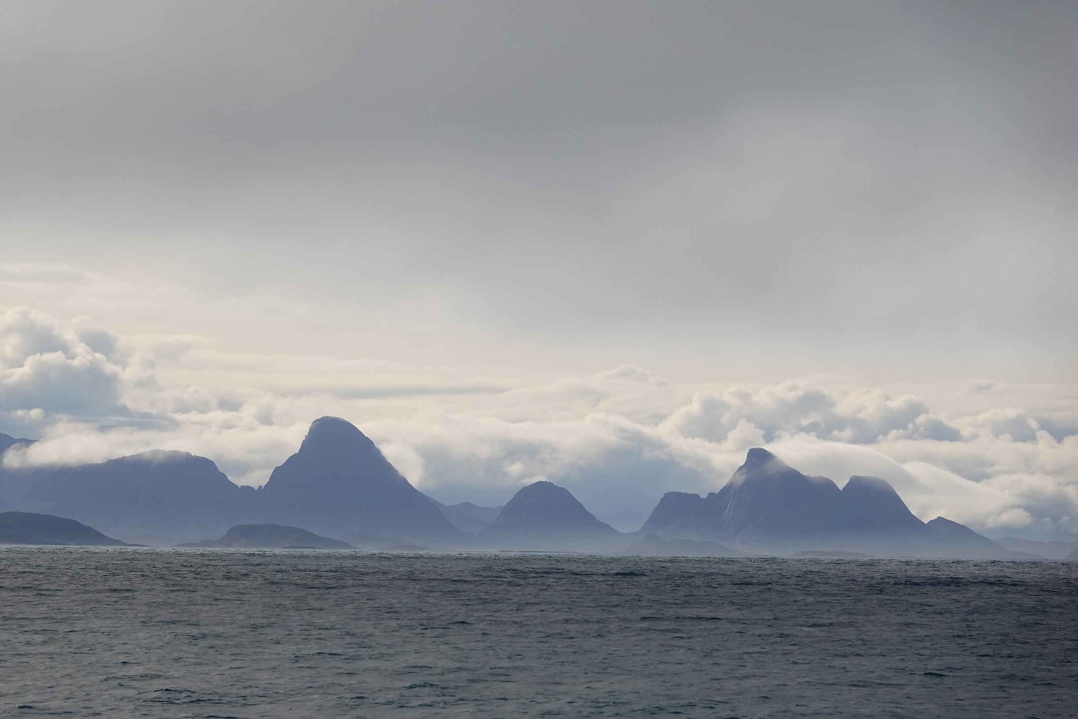
Photo by Hugo

Photo by Hugo
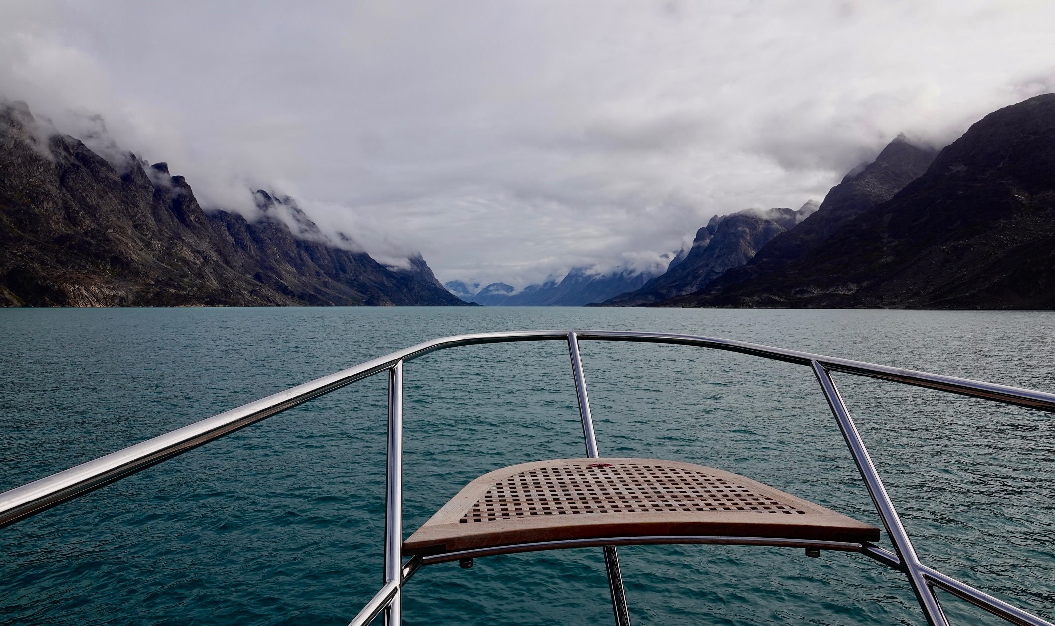
Photo by Hugo
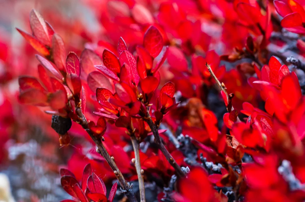
Photo by Ken Burton

Photo by Ken Burton

Photo by Ken Burton

Photo by Ken Burton

Photo by Ken Burton

Photo by Jonathan

Photo by Ken Burton
Southward
/We ghosted through Disko Bay, leaving Ilulissat and her mighty glacier behind. Along our route, we passed a number of giant bergs, calved from the Sermeq Kujalleq ice flow. Richard launched his drone and took a few shots that provide an idea of the size and scale of the bergs in this area. We angled southwest, then south and anchored in Sisimiut, the second largest city in Greenland. Continuously inhabited for the last 4500 years, Sisimiut today is a colourful, eclectic town with a healthy mix of tourism, commercial fishing (shrimp, halibut and cod) and supply forwarding operations (to the more remote hamlets along the Greenland coast). Guests and crew enjoyed walks ashore, visits to the museum and local shops.

Photo by Richard Smith

Photo by Ken Burton
From the sky
/The helicopter was red and it stood out against the powder blue sky. It could carry 11 passengers and that meant that our Arctic Guide, Ken Burton, and Renee would join the owners and guests for the scenic flight over the Sermeq Kujalleq ice flow. We had seen it from the land; we had seen it from the water; now it was time to see it from the air. The Bell 212 helicopter hammered the air and lifted off. "It was very loud," Renee told me later. "But luckily we all had headsets." The chopper flew from the airport directly to the ice sheet, about 30 miles inland and landed on a rocky promontory near the ice. "I felt like I was on the moon again," Renee laughed. "It was rock under the helicopter but out towards the edges, I found quartz and -- it was weird -- sand; there was really fine sand; it must have been moondust."
Out on the edge of the rocks, there were two round pods, which Ken identified as rescue pods, in the event that the helicopter became stranded and humans needed to spend a night or two before being rescued. From the rocky ledge, the Greenland ice sheet, stretched out in all its glory, as far as the eye could see. "The facts about this sheet are pretty impressive." I could tell Ken was about to share some of his encyclopaedic knowledge. "It is the second largest ice body in the world, after the Antarctic ice sheet. It's 1,500 miles long in a north-south direction, 680 miles wide east and west. When you're standing on top of the ice sheet you are at an altitude of 7,000 ft. The ice under your feet is generally more than 1.2 miles thick and almost 2 miles at its thickest point. If the entire 684,000 cubic miles of ice were to melt, it would lead to a global sea level rise of 24 feet."
The helicopter took to the skies once again and on this part of the trip, the group followed the ice topography -- from where the sheet spawns the glacier to where the glacier meets the sea. "It's not all the same," Renee said. "The ice sheet is pretty uniform, but as the river of ice gets closer to the sea, it looks different."
"A relatively round, smooth surface dominates the sheet and glacier," elaborated Ken. "During summer, sinkholes on glaciers called moulins form on the sheet; that's where summer meltwater streams on the surface of the glacier finds a crevasse or other weak spot in the ice and begins to pour down through the ice." Apparently, Moulins look like holes in the ice, can be quite symmetrical. Water entering these holes may travel all the way to the glacial base, lubricating the land ice interface.
"But once the glacier meets the sea, things change dramatically," he continued. "The ice meets the seabed and the water; it starts to float. It cracks and breaks. Jagged teeth rise up from the stresses. Ice bergs are born."
They flew out over the sea, right over the spot we had hiked to the day before. Over the bergs and clear water, they found whales, swimming in the bays created by the bergs, their long pectoral fins shining beneath the surface, their liquid breaths erupting in to the air.
"It's hard to decide which was more mind-blowing -- the ice sheet or the whales," Renee told me in the wheelhouse.
Perhaps President Trump, who has recently expressed an interest in purchasing Greenland from Denmark, has been captivated by these extraordinary sights as well.
—Jonathan

Photo by Ken Burton
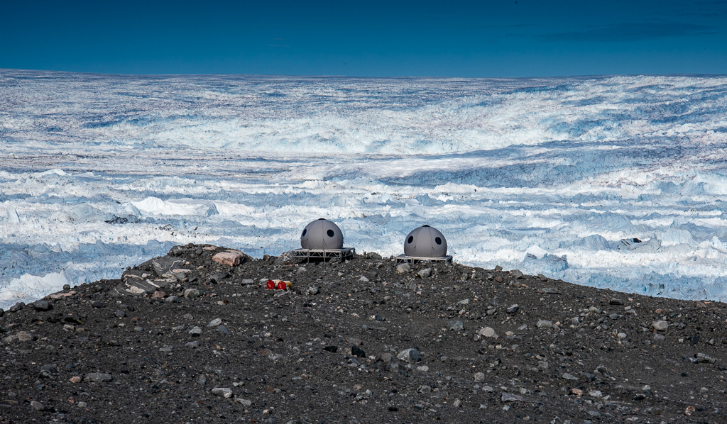
Photo by Ken Burton

Photo by Ken Burton

Photo by Renee

Photo by Ken Burton

Photo by Ken Burton

Photo by Ken Burton

Photo by Ken Burton
"And ice, mast-high, came floating by, as green as emerald." -- Coleridge
/We have not been on the dock since late July and so it was with a bit of excitement that we rose early, after just a few hours sleep, to prepare lines, inflate fenders, and ready Rosehearty to go along side in the small commercial port of Ilulissat. Heavy fatigue blanketed the crew but at anchor on this peaceful morning, with these surroundings, the fatigue softened the edges and did not detract from the focus of the preparations underway. There was satisfaction in the long hours, hard work, and achievements of the voyage so far. Strong coffee was served, one popular blend nicknamed the Nescafe Mochaccino turbo, which consists of 3 heaping teaspoons of Nescafe instant coffee, one teaspoon of hot chocolate mix, warm milk and an espresso floater.
The town of Ilulissat lay perched on the the rocky hills that surrounded the anchorage the blues, reds, greens, and browns contrasting with granite and ice. Small local fishing boats sped out of the harbour towards the open sea, their drivers weaving around bergy bits as if they were in racing cars, negotiating a slalom course. The wake from their boats angled outward, striking the hollowed out waterlines of the nearby ice bergs, sending out a sloshy reverberating slap of cold water against hard ice.
Rosehearty's presence at the commercial dock drew crowds. Behind us an rusty tramp steamer was being loaded with gravel. A bull dozer scooped up the material and unceremoniously deposited it into the gaping hold of the ship. Fishing boats of every size, shape and color lined the wharves. Line handlers, fork lift operators, stevedores, agents, and local families walked the dock to look at Rosehearty, the enormous white ship berthed in their town. Everyone waved.
To understand the Sermeq Kujalleq ice flow you have to see it from several different angles. It is not simply the enormous, fast moving glacier or the vast quantity of island-sized ice bergs that it calves off. To comprehend its size and volume, you have to connect the bergs to the glacier and the glacier to the actual Greenland ice sheet from which it emerges. The Greenland ice sheet covers 80% of the island and contains an estimated 2.7 million cubic kilometres of ice, the equivalent about 7% of all the fresh water on earth. And so on board Rosehearty, Captain Hutch and Ken, the expedition leader, had discussed three missions to provide perspective: first, there would be an overland hike to the glacier; second, tenders would carry all our guests to the leading edge of the flow, where the river of ice meets the water; and third, a local helicopter company would fly everyone over the flow, to see its connection to the actual Greenland ice sheet and get a sense of how the three components are stitched together to make up the whole.
Four taxis carried the team from the port to the beginning of the marked trail. I travelled with Hans. He had a broad face, narrow eyes and an infectious, disarming smile. Hans spoke English, Greenlandic and Danish. As we drove through town he pointed out the supermarket, a new brasserie that featured 6 different craft beers, and the local whale monger, where several varieties of fresh whale and seal could be purchased. The town was compact, very clean, busy with locals and tourists. Dozens of huskies were chained to rocks or housed in cages near the outskirts of town. Many puppies and juveniles, not chained, frolicked near the adult dogs. "They are on vacation right now," Hans explained. "When the snow and ice come, their work begins." Sledges lay stacked near the kennels. Greenland dogs, Samoyeds and Siberian Huskies seemed to make up the bulk of the breeds we saw. I read that all these breeds have closely spaced toes with webbed feet for gripping in snow. A unique arrangement of blood vessels in their legs protect them against frostbite. Dogs have been used for thousands of years in the Arctic, some breeds carefully designed for hauling and others (crossed with wolves) for hunting. The road ended at a sprawling construction site, where, Hans explained, a new visitor's center was being built. The frames of this new structure stood out against a blue sky. This was going to be a modern building, angular with huge plate glass windows. The Sermeq Kujalleq ice flow is a UNESCO world heritage site and welcomes many visitors from all over the world.
A simple boardwalk spans the distance between the road and the glacial viewing areas. Built about a foot above the ground, the boardwalk follows the contour of the land. It is wide enough for you and one companion, to walk side by side. This encourages quiet conversation but also uninhibited silence. Black rocks flecked with green lichen stand in bold contrast to tiny clumps of tundra flowers, furry mosses, wild blueberries. We were back to that "carpet of color" that Ken had described during our visit to the Inuksuk at Low Point. The boardwalk bends downhill, gradually snaking away towards the sea. An impressive, layered canvas unfolds -- the colourful flora of the tundra, the dark rocks, the sea, the ice. Gasps and exclamations compete against the staccato of camera shutters, breaking an otherwise silent landscape.
Describing the Sermeq Kujalleq glacier is difficult, but photographing it is even harder. You snap the picture, then look at the image on the small LCD screen. "No that's not it," you think to yourself and then try another shot, perhaps with less zoom or a different lens. How do you capture a river ice that seems still and frozen on the one hand but is actually moving -- rapidly by glacial standards -- on the other? Cracks and groans can be heard; weird shapes emerge -- jagged teeth, smooth hillocks, ice boulders packed with dirt and debris. We sit on benches overlooking the scene. We drink tea -- steaming mugs of Rooibos Chai tea. Smoky tendrils, laced with clove, warm our faces. We put our cameras down and just look, letting the mind's eye, rather than the camera, sear the image in to our memory.
In the afternoon we gear up, load in to the tenders, and head to sea. It is a special place, where an ice floe of this size, meets the ocean. Island sized bergs stand motionless, their true mass below the surface. We glide among the bays created by the ice, wide deep channels, lined ice-blue cliffs. Glaucous gulls and Northern Fulmars swoop and dive. A pair of whales surface, expelling huge breaths, then arching back into the sea. We shut off the engines and drift. If you are lucky enough to be in the Arctic on a still summer's day, the sounds as much as the sights will accost you. The groan of a glacier, the crack of a piece of an ice berg, splitting and falling in to the sea, the lap of a wavelet rebounding off the hollowed out edge and an ice strip, the drips of water streaming off the sunward facing edges of the ice, the whoosh of whales. "Everything seems louder," comments Simon. "I think it is because the air is so dense, even the smallest noises are amplified."
The cold begins to penetrate our layers. We pull our hats lower, and our neck warmers higher. Ethan, driving Wolfie, indicates that they are headed back to port. Mark, in command of the Nouvarania, nods thankfully. Even in a full Mustang suit, with balaclava, mittens and boots, he is starting to feel the cold. Up on to a plane jump the boats, parting an icy wind on their way back to Rosehearty.
—Jonathan

Ilulissat colors with Roeshearty’s masts


Photo by Ken Burton

Photo by Hugo
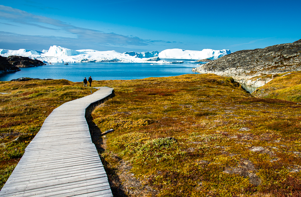
Photo by Ken Burton

Photo by Hugo

Photo by Ken Burton

Photo by Hugo

Photo by Ken Burton

Photo by Hugo
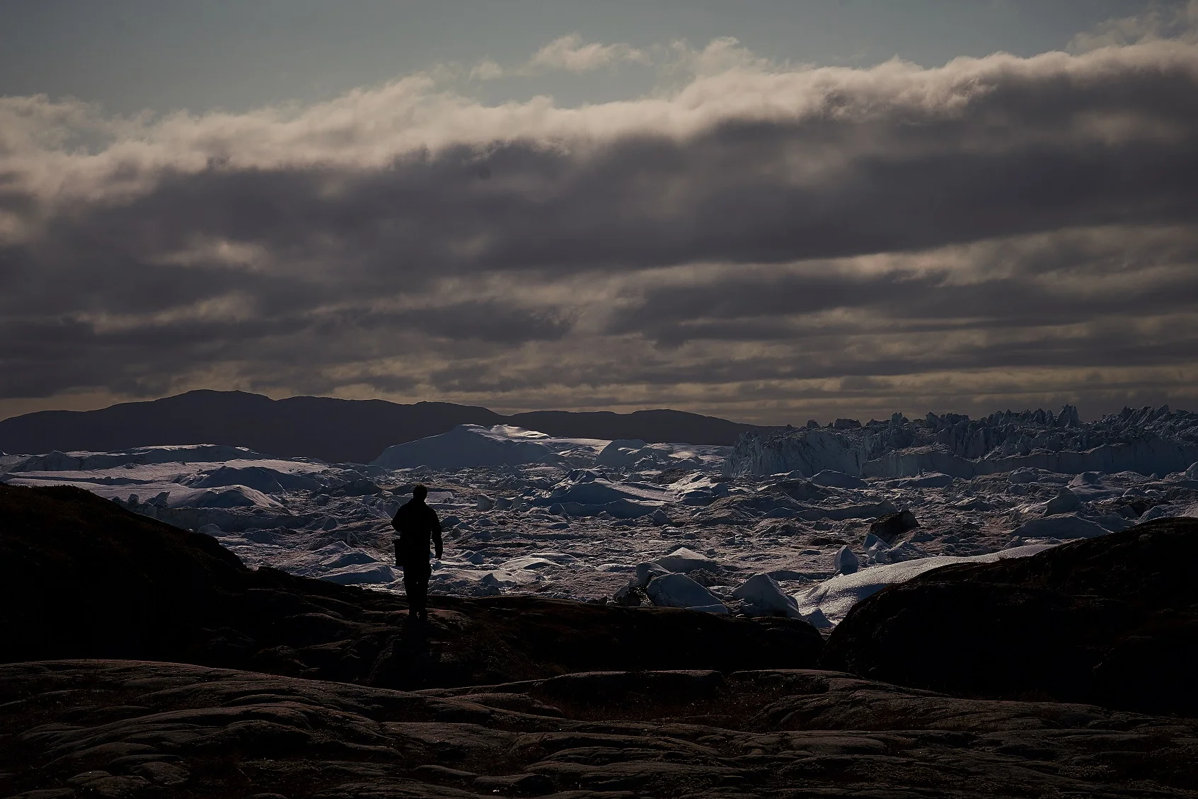
Photo by Ethan


Shape Shifting
/The island of Disko broke the wind and the waves. Qeqertarsuaq is the Inuit name for Disko and it means "the large island". With its 3300 square mile area, one can understand how this behemoth might have received this moniker. Rosehearty roared into her lee with double headsails, 25 to 30 knots of breeze aft of the beam, a 2 meter sea on the quarter. We had just sailed more than 400 miles across Davis Strait. And then everything went quiet. Sails went limp and had to be furled away; the sea became smooth. And then, the icebergs appeared. Now we have seen plenty of icebergs on this voyage, but what we had not seen was the quantity and size of the bergs that came into view.
On every part of the horizon, everywhere we looked, big bergs stood, jutting in to the sky. The ice sheets and strips of Lancaster sound were impressive – and dangerous – but these mountains of frozen water were something entirely different. The sheer bulk of what we were seeing left us in awe. There was plenty of deep water between the bergs and very few bergy bits. This layout, combined with the great visibility and kind sea conditions, allowed us to become absorbed in the view. The thing with icebergs is that when you see them from a moving ship, they change shape and color as you drive passed. The sun moves the shadows around. Refraction plays tricks on you: small bergs become big bergs; their masses floating above the sea.. The clear air makes things that are very far away seem closer. Ice bergs shapes shift. On the flybridge, we described what we saw – one looked like a gaff-rigged topsail schooner, another was the shape of a perfect pyramid from Egypt, and a third, we were convinced, looked like a Scottish terrier, resting on all fours.
The ice bergs we were seeing are calved from the mighty Sermeq Kujalleq glacier, situated next to the picturesque town of Ilulissat. This icefjord is a designated world heritage site. The UNESCO site explains, “One of the few places where ice from the Greenland ice cap enters the sea, Sermeq Kujalleq is also one of the fastest moving (40 m per day) and most active glaciers in the world. Its annual calving of over 46 cubic kilometres of ice, i.e. 10% of all Greenland calf ice, is more than any other glacier outside Antarctica. The combination of a huge ice-sheet and the dramatic sounds of a fast-moving glacial ice-stream calving into a fjord full of icebergs make for a dramatic and awe-inspiring natural phenomenon.”
We ghosted into the Ilulissat anchorage at 0100 local time. The sky burned orange. A waning moon rose. Time for a few hours sleep in this cradle of bergs.
—Jonathan
Photo by Hugo

Photo by Hugo

Photo by Hugo

Photo by Hugo
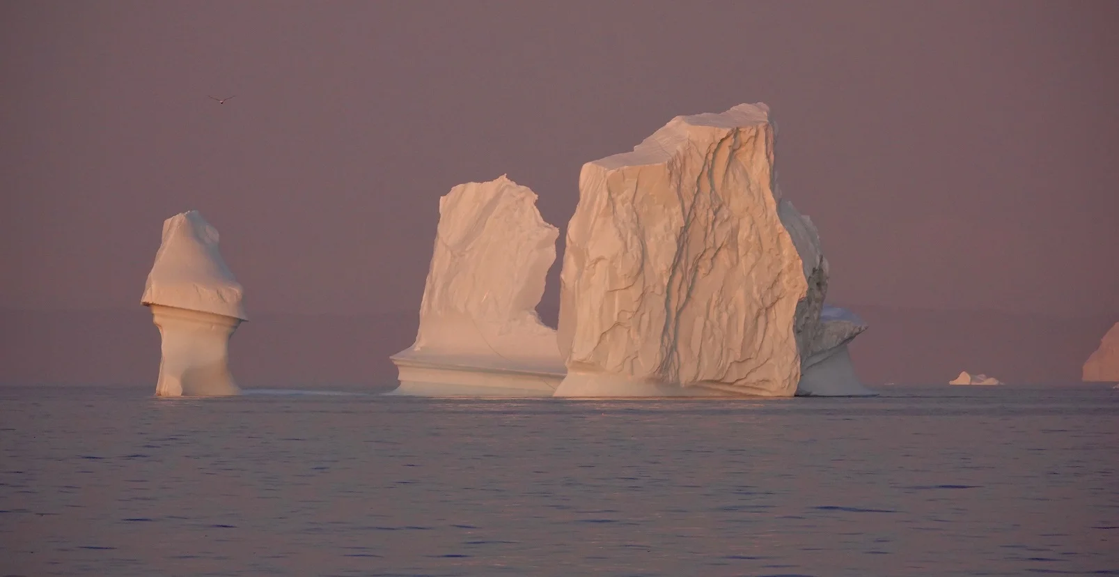
Photo by Hugo

Photo by Hugo
In the Beginning
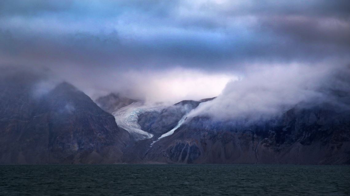
/If you look at a detailed nautical chart of Baffin Island, you will see that the east coast is heavily indented with deep bays and fjords. These are rarely visited since ice can be abundant, winds high, and depths too great to anchor. And so prior to our departure from the Canadian Arctic and before crossing Davis Straits towards Greenland, Hutch suggested that we tour one of the larger fjord complexes. He chose the Buchan Gulf about hundred miles from Pond Inlet. With a stout easterly funneling through the narrow channel that leads to Davis Strait, we left Pond behind and made for open water.
Buchan Gulf is comprised of four distinct arms cutting from Davis Strait into the interior of Baffin Island; each of these arms is more than 20 miles long, lined with mountains 1000 meters high, with depths plunging to 500 meters. The whole way south, the Baffin Coast was shrouded in low cloud, misty rain, and fog. When we were about ten miles out, the curtain lifted temporarily and we caught glimpses of high rocky mountains, snow, winding glaciers. But no sooner had we seen the coast, that it disappeared once again behind the thick shade. "If it's too foggy when we get to the entrance, we won't go in," announced Hutch. When doing our route planning, he had discovered that the electronic charts for the area were incorrect; land masses were placed almost half a mile from their actual positions. Our tour of the fjords would be done with our eyes, radar, dividers, parallel rules and a Danish paper chart. We would keep a careful watch on our depth since there were very few soundings on the chart; in these waters, 200 meters can turn to 10 meters very quickly. It had taken us all day to get to this fjord; would we have to turn away?
As we swung west onto our final heading we were teased several more times with glimpses of what lay behind the curtain but each preview lasted only a few minutes. On we pressed into the unknown. Fortunately, the curtain went up just as we arrived at the mouth of the fjord. The show was on. We entered a foreign land. Sheer cliffs plunged straight down into obsidian water. The cliff faces looked as if an artist had taken his spatula and smeared the canvas with every shade of brown and red. Hard blue glaciers clung to rocky ravines. The ice was flecked with boulders and other debris. Every once in a while we spotted the tops of the mountains, where the clouds parted momentarily. The summits were sharp, toothlike. Everyone came on deck, wide-eyed. What was this place?
I said to Germain, "It feels like the land that time forgot.:" "Or maybe," he replied, "the land at the beginning of time." The shapes were alien, cold, hard. Everything felt raw. When I looked at the glaciers I expected at any time to see a group of abominable snowmen, emerge from an icy cave, hold their furry arms skyward, and shake their fists at the intruders. I imagined huge megalodon still hunted the icy waters and pterodactyls still patrolled the skies.
—Jonathan

Photo by Jerry Herring

Sunlight lured us in. Photo by Jerry Herring

Clouds parted to reveal the toothy summits. Photo by Jerry Herring
Hard blue glaciers clung to rocky ravines. Photo by Jerry Herring

We entered a foreign land. Photo by Catherine Carr

I expected at any time to see a group of abominable snowmen, emerge from an icy cave, hold their furry arms skyward, and shake their fists at the intruders. Photo by Hugo